SPREAD - Estimation of Fuel Properties for Fire Risk Prediction
Contact Persons
| Felix Morsdorf | Erich Meier |
Keywords
Airborne laser scanning, imaging spectroscopy, fuel-type/properties mapping, canopy structure, radiative transfer modelling
Abstract
The European research project SPREAD investigates the main wildland fire domains fuel management, fire behavior, fire effects and fire management. SPREAD provides a framework for the development and implementation of an integrated forest fire management system for Europe. The assessment of fuel parameters is carried out throughout Europe covering the Mediterranean but also the boreal vegetation types of Fenno-scandia. SPREAD consists of a consortium of 26 partners from 14 countries (including Finland and Canada). GIUZ (Geographisches Institut der Universität Zürich) is involved with an interdisciplinary team built by representatives of the wildland fire research group (GIS-SNP/GIUZ) and the Remote Sensing Laboratories (RSL/GIUZ). The GIUZ team focuses on fuel parameter description, fire occurrence and risk mapping. For the present the work on fuel parameters is relevant.
Accurate fuel data represent a key element for reliable wildfire behaviour and propagation model-ling. Most fuel maps suggest homogeneous or uniform conditions within fuel classes (types), although greater variations can be found within vegetation types or plots than between. Examining fuel beds, a great variety in structure (vegetation height, bulk density, dead to live fuel ratios, etc.) and spatial distribution appears. The acquisition of precise fuel data in the field is costly, time and labour intensive and limited in its spatial extent. It is therefore an important task of this project to develop and test remote sensing methodologies that allow fast and reliable detection of high resolution fuel data for operational use in fire propagation modelling over large areas.
By combining different new airborne sensors, the University of Zurich will develop fuel detection methods that allow a 3D-representation of the whole fuel complex. For this purpose, static fuel properties (i.e., fuel type, geometry, location and structure of the different fuel bed strata / vegetation layers) as well as time dependent dynamic fuel properties (i.e., distribution of fuel moisture, proportion of dead-live material) will be characterised.
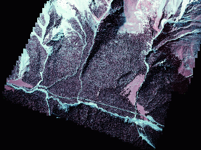
The test area for retrieving the remote sensing data is located in the Swiss National Park . The site was chosen due to the main vegetation type resembling boreal forest, which is one of the worlds largest biomes, covering dry surface. An orthoimage containing the test site can be found below :
Project Status
The project started in February 2002 and will run for three years. The extensive field campaign took place in the Swiss National Park in Summer/Fall 2002. Two surveying flights with hyperspectral and LIDAR imaging systems were conducted during this period. Intensive field measurements provided the relevant reference data for calibrating and validating the acquired remote sensing data, and will enable the development of future methodologies.
The data collected during this field campaign will be complemented through structural information of more than 2000 trees gathered by the Swiss Federal Institute for Forest, Snow and Landscape Research (WSL).
Results
The assimilation of spectral and geometrical remote sensing data (DAIS,ROSIS,LIDAR) into retrieval algorithms present a very promising approach to allow a 3D-representation of the whole fuel complex. This new approach can be used to monitor the continuous spatial distribution of the forest canopy attributes at high spatial resolution providing quantitative information to support fire management decisions. We therefore developed and tested new methodologies based on remote sensing data to derive high resolution fuel bed properties such as fuel type, canopy structure and geometry, biomass, and fuel moisture. These properties were applied in the simulation of wildland fire spread using the commonly used model FARSITE. Results of simulations using four different resolutions are displayed as Time of Arrival (ToA) and Rate of Spread (RoS) below. It was found that at high resolutions, topographic features explicitly work as breaklines for the fire spread, while at larger resolutions the fire was not hindered.
Literature
List of LIDAR Publications
Remote Sensing Methodologies
Imaging Spectroscopy
Laserscanning (LIDAR)